Introduction
Australians are the worst greenhouse polluters on the planet - with the possible exception of a couple of small oil-rich Middle Eastern states - and are having to pay a high price for their practices
|
|
|
The aim of this page is to make another small attempt to force the Australian people out of their apathy regarding greenhouse/climate change. We must quickly start to change our life-styles and make substantial steps toward sustainability.
Australian governments and the Australian people have done very little to act on greenhouse pollution, so there seems to be a crude justice in this looming disaster. If there was a god, you would have to conclude that he was punishing Australians for their arrogance and for damaging his creation.
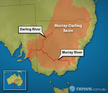
Ironically, both the current PM, Kevin Rudd, and the previous PM, John Howard, are believers; yet both support the coal industry at the expense of the health of 'God's creation'. Both are against sufficient and sufficiently prompt action against climate change. The loss of the irrigation industries in the Murray-Darling basin will cost the country hugely. Kevin Rudd and others who are slow to tackle the causes of climate change seem to forget that if renewable energy replaced coal, jobs and wealth generated by the renewable energy industry would tend to replace those lost in the coal industry.
|
|
Drought
The south-eastern part of Australia is currently (late 2008) in a drought that has lasted more than seven years. This has greatly exacerbated an already deteriorating situation. It has brought the decline in the health of the Murray-Darling Basin to a head earlier than would have happened otherwise.Research into the climate of the last 30 years jointly by the Bureau of Meteorology and CSIRO (released Sept. 2007) has indicated that the drought is more likely due to a permanent change to the Walker circulation than just to a slow change from the drought producing El Nino back to the rain producing La Nina. Read about it on the ABC. The report indicates that annual rainfall in the Murray-Darling Basin is likely to decline by from 2-5% by 2030. Significantly, most of this decline will be in winter and spring.
|
|
Drought again, 2019
|
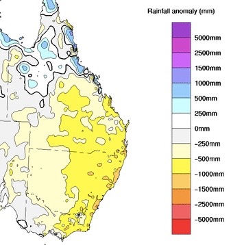
As can be seen most of the catchment area of the Murray-Darling system is coloured yellow indicating a deficit of between 500 and 1000mm for the three years. This means that it received between 500 and 1000mm less than would be expected on average over the three years.
It can be calculated that the deficit in rainfall over the three years is about 300 TL (terralitres) and that is about equal to the quantity of water required to fill 170 million olympic swimming pools.
At the time of writing (2019/12/19) there were unprecedented fires west of Sydney, there was an unprecedented heatwave over south-eastern Australia and the previous day had been the hottest on record for the whole of Australia. It had recently been reported that average farm incomes had fallen by 22% due to climate change.
The
Morrison government was continuing to refuse to take serious action to reduce Australia's emissions.
Increasing temperatures
|
|
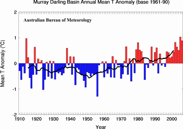
Temperature has been increasing, especially since about 1950 |
Temperatures in the Murray-Darling Basin will
continue to rise and runoff will continue to decline. Of course there will be
some good years to come, but in general the trend will be down.
Rainfall has decreased
|
|
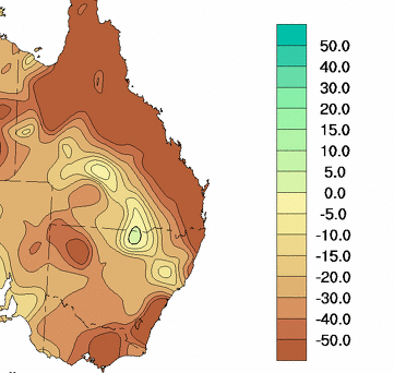
From the Bureau of Meteorology |
The colours indicate trends in millimetres of rain per ten years. That is, the darkest brown colour shows places where there has been a decline of at least 50mm in the ten-years rainfall. (I find this way of stating the trend a bit difficult to understand, but it seems to equate to a decline in average annual rainfall of at least 5mm each year for the 36 years. It is easy to see that this is a huge decline in rainfall, totalling a reduction of 180mm in average annual rainfall over the period.)
From the map, the Murray Darling basin in general is not suffering quite such a decline in rainfall as is Gippsland and the NSW SE coast, but there is a decline of between 20 and 30mm/10yrs over a very large part of the basin. Perhaps more importantly, the trend is between 30 and 40mm/10yrs over some of what has been the best-watered part of the basin.
|
|
Decreased run-off due to higher carbon dioxide levels
Research done by Anna Ukkola and Albert Van Dijk reported on The Conversation on 2015/10/21 links higher atmospheric carbon dioxide levels with reduced run-off in "subhumid and semi-arid" part of Australia. The map included in The Conversation article indicated that the wetter parts of the Murray-Darling Basin are all within these zones.Decreased run-off due to more frequent burning
Research has been done, I think by the CSIRO, indicating that forest that has been burned in the last few years takes up a larger percentage of the rainfall than mature forest, leaving less to run off. It seems that recovering forest has a greater need for water than mature forest. It therefore is more effective at using the available rainfall for its own needs rather than allowing that rainfall to run off.Other research indicates that bushfires will in future be more frequent in the headwaters of the Murray Darling due to the higher temperatures.
Update late 2019
|
Research on likely decline in flows in Murray-Darling
In September 2003 Earth Tech Engineering produced a report titled "Preliminary review of selected factors that may change future flow patterns in the River Murray" for the Murray-Darling Commission. The report looked at a number of factors that were likely to produce changes.Climate change (research done by Francis Chiew, University of Melbourne) was seen as likely to reduce flow by 5% (1100GL per annum) in the next 20 years, with the possibility (worst foreseeable) of causing a reduction of 20% (4400GL per annum) in the same period. (I find it unlikely that the decline will be as small as 5%, I will continue researching the matter, and would welcome information on the subject from readers. Perhaps global dimming has been a significant factor and will continue to be?) In 50 years Chew suggested a likely 15% (3300GL per annum) reduction and possible 50% (11 000GL per annum) reduction in stream flow due to climate change.
The likely impact of reforestation was researched by Lu Zhang of CSIRO/CRCCH (Commonwealth Scientific and Industrial Research Organisation/Cooperative Research Centre for Catchment Hydrology) for the same report. The likely 20 year impact was seen as a 600GL reduction in annual flow with a possible reduction of 1400GL. The likely 50 year impact was seen as a 1100GL reduction with the worst foreseeable reduction being 2100GL in annual flow.
Other factors such as increased groundwater extraction, changes in drainage and returned flows, and construction of farm dams were also expected to cause significant reductions in future flows.