Bicycling in Mandurah
I use my bike on most days, often just to the local shopping centre or a short relaxing ride along the lagoon coast, but going for a longer bicycle ride on Sunday mornings has become something of a routine for me. The roads are quieter in the mornings, especially Sunday mornings; if you want to see Mandurah at its best, most beautiful and peaceful, get up early. Before setting out for a long ride I usually try to think of somewhere I can ride that is different and a bit challenging. On a particular morning in early October 2023 I decided to ride over all the pedestrian/cycling bridges that I could think of in Mandurah; there are six of them. That's what got me started on this page, but there are plenty of other cycling opportunities in Mandurah, a number of which I've discussed below. My favourites are those that follow the coast, either the Indian Ocean coast or the Peel lagoon coast, or rides that take me through any of the many beautiful parks in Mandurah. Some of these follow what were natural water courses. And central Mandurah itself is a great place for an exploratory ride.
Contact: David K. Clarke – © |
|
|
|
Sunrise over the Peel, seen from an early morning bike ride, a little to the north of Mandurah Quay and a kilometre of so south of the Estuary Bridge. (Other photos taken in the same area are on another page on this site.)
|
IntroductionMandurah has been named Australia's top tourist town in 2023.I live in Mandurah so I am familiar with many of its attractions. One of the top attractions has to be the Giants. Four of the Mandurah giants could be visited in one longish bike ride, the fifth one would probably need a ride of its own - visit the nearby geologically significant thrombolites at the same time. (Also see Thomas Damo's Giants of Mandurah.)
There are paths along both the ocean coast and the lagoon coast, and along the Serpentine River (that runs into the Peel lagoon) and paths that follow various minor water courses scattered throughout Mandurah.
Getting to MandurahMandurah is about 70 kilometres south of Perth, the largest city in, and capital of, Western Australia. There is an excellent electric train service between Perth and Mandurah; about 50 minutes travelling time.
Bicycles can be taken on the trains outside of rush hours (morning rush hour into Perth and afternoon rush hour back to Mandurah). Bicycles are not allowed in Perth Underground station. For more on the conditions see TansPerth.
Bicycling is good for you and good for the environmentThe advantages of bicycling:
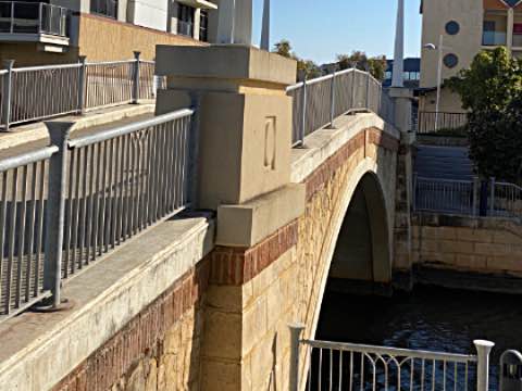
Pedestrian/Cycling BridgesMandurah has six bridges that are only for pedestrians and/or cyclists that I know of. They are at the following locations:
Photos of the pedestrian/cyclimg bridges
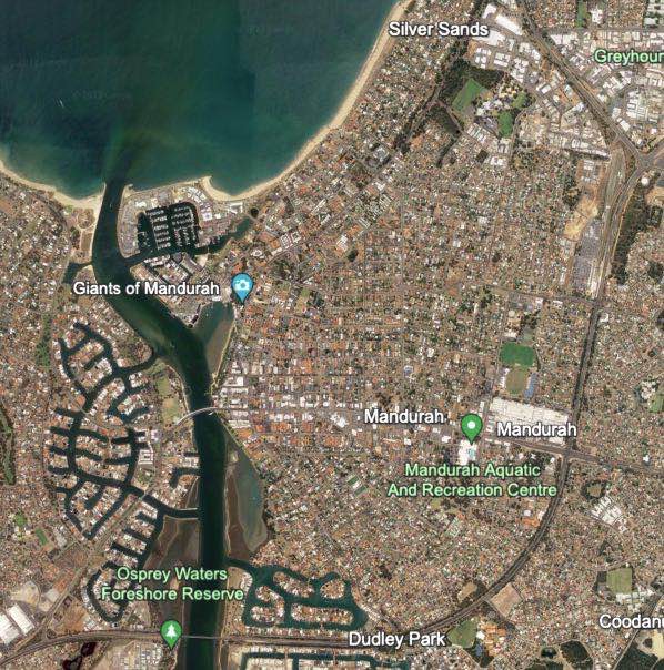
MapsAll six pedestrian/cycling bridges are in this part of Mandurah.I've written a little about cycling in central Mandurah elsewhere on this page. There's a lot of interest, and good cycling paths, on both sides of the estuary inlet.
Maps for individual pedestrian/cycling bridges follow.
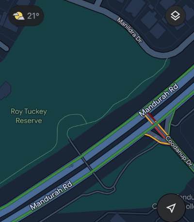
Map: Bridge 1This bridge is over the Mandurah Road at Roy Tuckey Reserve to the west of Pinjarra Road.I suspect that at least a part of the reason it was built was to allow students to safely cross this very busy road to Mandurah Catholic College, which is nearby on the south side of Mandurah Road.
On the map it is lower centre.
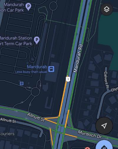
Map: Bridge 2This is the biggest and most impressive of all the pedestrian/cycling bridges in Mandurah. It crosses Mandurah Road and the Mandurah-Perth railway line just north of Mandurah Station.
The bridge is shown near the top of the map. There is a sharp corner that cyclists might want too dismount for on each side.
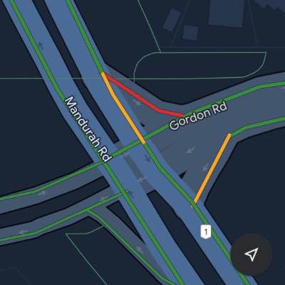
Map: Bridge 3This bridge crosses over Mandurah Road at its intersection with Gordon Road. The approaches are steep.This bridge was probably built to allow safer pedestrian (and cyclist) access to the commercial development immediately to the west.
It is shown toward the top of the map.
|

|
|
Looking west from the footbridge at Dolphin Quay (Bridge 4) shortly after sunrise.
|
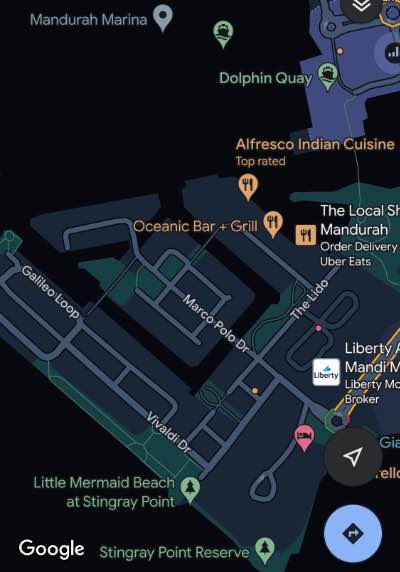
Map: Bridges 4 to 6I've called the high bridge between Keith Holmes Reserve and Dolphin Quay Bridge 4. On this map it is on the upper right, between the words 'Local' and 'Cuisine'.Bridge 5 is a short, low bridge across a canal east of Cannaregio Square and west of The Palladio. On this map it is in the centre just below the word 'Bar'.
More opportunitiesMore bridgesYou can ride a loop that includes the Town Bridge and the Estuary Bridge. This is covered in the 'Bridge Loop Ride' map produced by Tourism Mandurah. |
Dawesville Bridge at 'The Cut', southwest end of Endeavour Island
|
|---|

|
The Dawesville channel is artificial and is what makes Endeavour Island and island. There are combined walking/cycling paths below the roadway on both sides of the bridge. |
|
There are shared use paths along The Cut on both ends of the bridge.
If you go from the south side of Dawesville Bridge to the ocean coast you will find a very quiet cycling path the follows the coast further to the South. At the northern end of the bridge, on the lagoon side, Estuary Place will take you to one of the Mandurah Giants.
|
The only cafe I've found to be open relatively early (7am) nearby on the northeastern side of The Cut (anywhere near The Cut for that matter) is LeBelle Patisserie. Open every day but Mondays.
There is a cycling and walking path below the road traffic level on the far side of the bridge. There is also stairs down to the water. There are good views of the estuary entrance from the bridge.
Waterside paths; Endeavour Island
Ocean side of Endeavour IslandThere is a paved path along much of the ten kilometres of the ocean side of the island from the Dawesville cut to a kilometre or so short of the original estuary entrance at central Mandurah - and a very quiet path along the coast for several kilometres south of the cut too. There are a number of gaps in the walking/cycling path at the southern end, where one has to travel along roads but the shared-use path in northern section is continuous for about three kilometres. One of the Mandurah Giants is in this section.
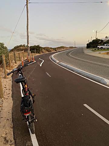
This is a newly opened section of shared use (pedestrian/cycling) path in Halls Head. It runs from Janis Street about 1.3 kilometres northward around to Robert Point (near Tod's Cafe) on the western side of the estuary mouth. This section had been under construction for perhaps the last six months of 2023. It is as good a quality surface as any I've come across in Mandurah. There is none of the 'bump-bump' that you get on the concrete paths. My Smart Motion E20 ebike in the foreground.
Photo iPhone 11 pro, 2024/01/28, early morning
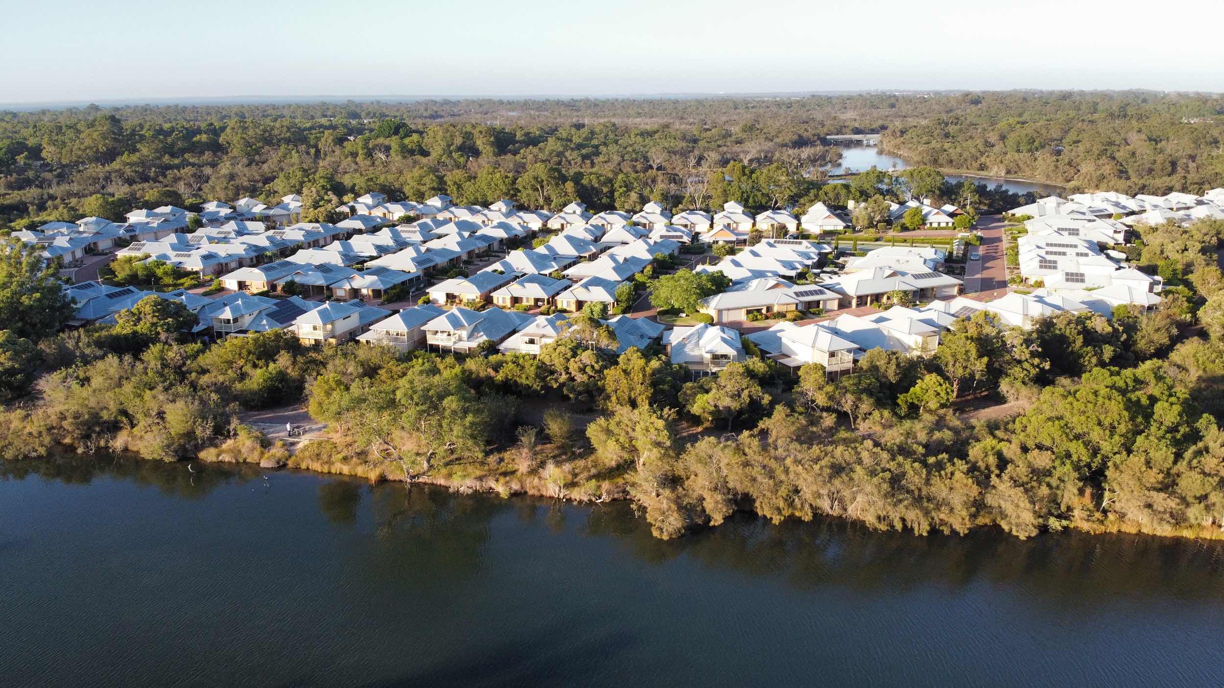
Lagoon side of Endeavour IslandThere are also shared-use paths, mostly concrete-paved, along the Peel lagoon side of the island, via Novara Beach and Foreshore Reserves nearly all the way from the Estuary Bridge for seven kilometres to west of the Falcon shopping centre. Through the beautiful Len Howard Conservation Park, in the centre of this section, most of the path is narrow, earth surfaced and a bit rough rather than hard-paved (and some of these paths have been unnecessarily widened at the expense of the native bush). From the Len Howard Conservation Park paths can be followed to the north-east close to the lagoon to the beautiful Osprey Waters Reserve as far at the Estuary bridge. |
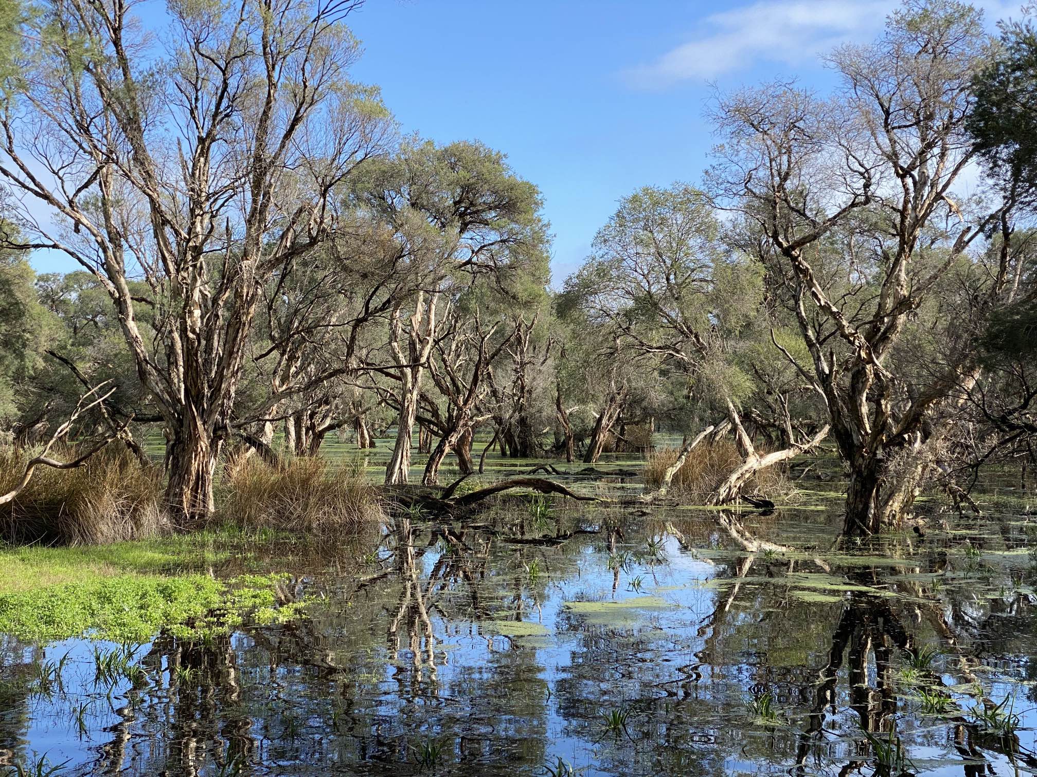
The big seasonal paperbark swamp in Len Howard Conservation Park
|
|---|
|
This seasonal swamp is in the middle of the LHCP. There is a resident mob of kangaroos, and a good walking/cycling path around the swamp. |
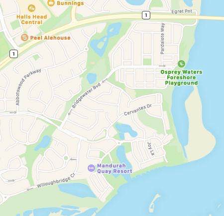
Water courses
The second goes from the big park at the northeastern end of this between Whistler Drive and Shoveler Crescent to Osprey Waters Reserve (mentioned in the Waterside paths section of this page).
In the map on the right the first ride follows the long green area from lower left to upper centre. The second ride is along a concrete path that goes through the green area connecting the big lake area to Osprey Waters.
Waterside paths; east of the Estuary Bridge
Serpentine River
And there is a well paved path around St Ives retirement village (drone photo on the right). St Ives is in a loop of the river which is in the foreground and the background in the image. The path runs along the river in several places.
Central Mandurah
There are paths on both sides of the main estuary entrance as well as along the ocean foreshore in Central Mandurah. The great majority of the shops are on the eastern side of the estuary entrance but the recreation area, the wind organ and the war memorial on the western side are all worth a visit. The cycling and pedestrian bridge that I've number four to six and covered elsewhere on this page are in the Central Mandurah area. There's a lot of bird life around Mandurah, as you'd expect for a place between ocean and a big estuary, and, of course, Mandurah is known for its dolphins. A number of the bird species of Mandurah are shown on another of my pages.
From my home in Erskine I have three main options for getting to the town centre, along the ocean coast, along the lagoon coast, or the short, direct, rout. And then there's always just meandering through the streets and parks, finding places I haven't visited before.
South of Dawesville BridgeSouth west of Dawesville BridgeMandurah is a fast growing city in what was, not so long ago, a mostly undisturbed area. It seems that the soil was too poor for it to be attractive for farming and whatever pastoralism there was didn't much impact the more coastal areas.However, development has come to Mandurah in a big way in the last few decades.
This first image was recorded just south of the Dawesville Cut. It seems to be largely untouched native heath vegetation, outside of the shared walking/cycling path.
The high-rise buildings are at The Cut Golf Course.
Tree graveyard
It was the third photo (below) that gave a clue to what happened here.
I suspect that when the bush was cleared for the golf course the developers were not allowed to burn all the removed vegetation so they carted it over the foreshore dune and dumped in the 'tree graveyard'. Google Earth gives the impression that the 'tree graveyard' extends for the kilometre or more of the golf course. We can only hope that the heath will eventually recover where it has been so greatly disturbed by the machinery and the dumping of the ripped out bush. Note the kangaroos in the distance on the golf course.
As for cycling, you can leave the coastal path and go inland via the golf course buildings or you can continue perhaps a half a kilometre further south before the golf course and coastal trail seems to end.
South east of Dawesville BridgeThe somewhat arbitrary boundary between the roughly round Peel Lagoon and the longer and narrower Harvey Lagoon to the south is between the Dawesville Cut and Point Grey on the inland side.
These water birds were roosting on a jetty about 500 metres south of the Warrungup Springs Reserve boardwalk.
Warrungup Springs Reserve
There are also trails trails through the bush on the sand dunes fronting the Harvey lagoon.
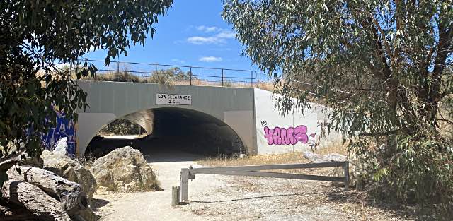
Black Swan Lake (Lakelands)
|
|
You can take your bicycle with you on the train at no charge outside of rush hours. Quoting TransPerth:
"Bikes are not permitted on train services travelling towards Perth city between the hours of 7.00am and 9.00am.
Bikes are not permitted on train services travelling away from Perth city between the hours of 4.30pm and 6.30pm."
|
|
|
|
There is a photo of the Marlee Reserve giant elsewhere on this page.
Related pagesExternal sites...Mountain Biking and Cycling in the Mandurah region, Tourism Mandurah. This page links to the following maps;Bridge Loop Ride map: Takes in the town area, the Town Bridge and the Estuary Bridge Relaxed by Nature map: Takes in Stingray Point, the Ocean Marina and then shows the trail along the coast to the north of Mandurah. Note that while the map shows a continuous trail there is in fact a gap of half a kilometres where you'll have to ride adjacent to Ormsby Terrace between Stewart Street and Henson Park. Mandurah Sea Explorer map: Covers from Mandurah Visitor's Centre to the ocean coast west of central Mandurah and along the coast as far as Falcon Bay. (I highly recommend this coastal ride.) Explore Mandurah's best cycling trails
On this site...Relating to Western Australia...A visitor's photographic recollection of WA A new resident's photographic impression of WA Fleabane eradication and other projects, Mandurah Mandurah volunteers; a page to connect them Peel Estuary and Mandurah, observations Perth: the good, the notable, and the ugly Western Australia, observations on its government
A visit to the south of WA
What can (and should) we be doing to reduce greenhouse gas emissions? |
IndexOn this page...Bicycling is good for you and good for the environmentBlack Swan Lake and underpass to Marlee Reserve Bridges; Mandurah's Pedestrian/Cycling bridges Bridge 1: Over Mandurah Road at Roy Tuckey Reserve Bridge 2: Mandurah Railway Station Bridge 3: Intersection of Mandurah Road and Gordon Road Bridges 4 to 6: Dolphin Quay area Dawesville Bridge Estuary Bridge More bridges Town bridge Central Mandurah East of the Estuary Bridge: Coodanup, Greenfields Getting to Mandurah Introduction Lakelands: Black Swan Lake and Marlee Reserve Lagoon side of Endeavour Island Maps section Marlee Reserve Marlee Reserve giant More opportunities Ocean side of Endeavour Island Pedestrian/Cycling Bridges Photos of the pedestrian/cycling bridges Related pages Serpentine River South of Dawesville Bridge South east of Dawesville Bridge South west of Dawesville Bridge Tree graveyard Underpass, Black Swan Lake to Marlee Reserve Warrungup Springs Reserve Water courses Waterside paths |